

Preview
Document Type
StillImage
Contributing Institution
Maine State Library
Identifier
BOWASH8423 p26
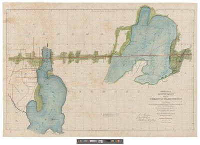
Description
Map was surveyed on the part of the United States in 1843 by Folliet T. Lally, Civil Engineer under instructions from Major J.D. Graham, Topographical. Engineers., Principal Astronomer and Head of the Scientific Corps; 1 map in 30 sections. Part 26: Longitude 73.03-73.25 Latitude 45
Exact Creation Date
8-9-1842
Language
English
Keywords
Maine; Canada; New Brunswick; Quebec; Northeast Boundary Dispute; Treaty of Washington 1842; Webster Ashburton Treaty; Bloodless Aroostook War