

Preview
Document Type
StillImage
Contributing Institution
Maine State Library
Identifier
BOWASH8421 p3
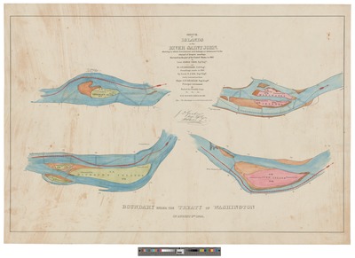
Description
Islands in the River Saint John, showing to which government each belongs, as determined by the channel of deepest soundings / surveyed on the part of the United States in 1843 by Lieut. George Thom, Topographical Engineers ; soundings made in 1843 by Lieut. T.J. Lee, Topographical Engineers under instructions from Major J.D. Graham. Topographical Engineers, Principal Astronomer and Head of the Scientific Corps, ; drawn by J.F. Burgin. 4 map sections on 4 sheets : hand colored, mounted on cardboard
Exact Creation Date
8-9-1842
Language
English
Keywords
Maine; Canada; New Brunswick; Quebec; Northeast Boundary Dispute; Treaty of Washington 1842; Webster Ashburton Treaty; Bloodless Aroostook War; St John River