


Files
Download Map (866 KB)
Document Type
StillImage
Description
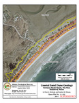
Maine Geological Survey, Open-File Map 11-102 (Superseded by Slovinsky and Dickson, 2023, Maine Geological Survey Open-File Map 23-81).
Publication Code
11-102
Publication Date
1-1-2011
Publisher
Maine Geological Survey
Supercedes
Superceded by
Location
York County
Map Type
Coastal Sand Dune Geology Maps (scale 1:4,800)
Map Scale
1:4800
Recommended Citation
Slovinsky, Peter A., and Dickson, Stephen M., 2011, Coastal sand dune geology: Fortunes Rocks Beach, The Pool, Biddeford, Maine: Maine Geological Survey, Open-File Map 11-102 (Superseded by Slovinsky and Dickson, 2023, Maine Geological Survey Open-File Map 23-81), aerial photo, scale 1:4,800. Maine Geological Survey Maps. 458. https://digitalmaine.com/mgs_maps/458
Rights Statement

No Copyright - United States. URI: http://rightsstatements.org/vocab/NoC-US/1.0/
The organization that has made the Item available believes that the Item is in the Public Domain under the laws of the United States, but a determination was not made as to its copyright status under the copyright laws of other countries. The Item may not be in the Public Domain under the laws of other countries. Please refer to the organization that has made the Item available for more information.