


Files
Download Map (24.2 MB)
Document Type
StillImage
Description
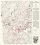
Maine Geological Survey. Map showing gravity contours and station locations.
Publication Code
GRAV
Publication Date
1-1-1993
Publisher
Maine Geological Survey
Location
Androscoggin County; Aroostook County; Cumberland County; Franklin County; Hancock County; Kennebec County; Knox County; Lincoln County; Oxford County; Penobscot County; Piscataquis County; Sagadahoc County; Somerset County; Waldo County; Washington County; York County
Map Type
Geologic Maps of the State of Maine; Gravity Maps
Map Scale
1:500000
Recommended Citation
Bond, Kevin R., 1993, Complete Bouguer gravity anomaly map of Maine and vicinity: Maine Geological Survey, map, scale 1:500,000. Maine Geological Survey Maps. 2064. http://digitalmaine.com/mgs_maps/2064
Rights Statement

No Copyright - United States. URI: http://rightsstatements.org/vocab/NoC-US/1.0/
The organization that has made the Item available believes that the Item is in the Public Domain under the laws of the United States, but a determination was not made as to its copyright status under the copyright laws of other countries. The Item may not be in the Public Domain under the laws of other countries. Please refer to the organization that has made the Item available for more information.