


Files
Download Map (1.5 MB)
Document Type
StillImage
Description
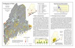
Maine Geological Survey. Map of Maine showing all earthquakes since 1814 for which magnitudes were measured or have been estimated. Also includes discussion of Maine's earthquake history, what happens during an earthquake, regional seismicity, and causes and risks of Maine earthquakes.
Publication Code
EIM
Publication Date
2003
Publisher
Maine Geological Survey
Map Type
Geologic Maps of the State of Maine; Earthquake Hazards; Earthquakes
Map Scale
1:2000000
Recommended Citation
Berry, Henry N., IV and Loiselle, Marc (compiler), 2003, Earthquakes in Maine: Maine Geological Survey, 11" x 17" color map, scale 1:2,000,000. Maine Geological Survey Maps. 19. http://digitalmaine.com/mgs_maps/19
Rights Statement

No Copyright - United States. URI: http://rightsstatements.org/vocab/NoC-US/1.0/
The organization that has made the Item available believes that the Item is in the Public Domain under the laws of the United States, but a determination was not made as to its copyright status under the copyright laws of other countries. The Item may not be in the Public Domain under the laws of other countries. Please refer to the organization that has made the Item available for more information.