


Files
Download Map (4.5 MB)
Document Type
StillImage
Description
Maine Geological Survey, Open-File Map 00-4
Publication Code
00-4
Publication Date
1-1-2000
Publisher
Maine Geological Survey
Related Item
James T. Adamik, Andrews L. Tolman, John S. Williams, and Thomas K. Weddle, Hydrogeology and water quality of significant sand and gravel aquifers in parts of Franklin, Kennebec, Knox, Lincoln, Penobscot, Somerset, and Waldo Counties, Maine; significant sand and gravel maps 18, 30, and 31
Supercedes
87-24b
Location
Kennebec County; Lincoln County; Waldo County
Map Type
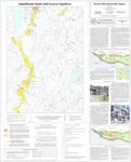
Significant Sand and Gravel Aquifer Maps (scale 1:24,000)
Map Scale
1:24000
Recommended Citation
Neil, Craig D. (compiler), Locke, Daniel B. (mapper) , 2000, Significant sand and gravel aquifers in the Weeks Mills quadrangle, Maine: Maine Geological Survey, Open-File Map 00-4, map, scale 1:24,000. Maine Geological Survey Maps. 1336. http://digitalmaine.com/mgs_maps/1336
Rights Statement

No Copyright - United States. URI: http://rightsstatements.org/vocab/NoC-US/1.0/
The organization that has made the Item available believes that the Item is in the Public Domain under the laws of the United States, but a determination was not made as to its copyright status under the copyright laws of other countries. The Item may not be in the Public Domain under the laws of other countries. Please refer to the organization that has made the Item available for more information.