

Preview
Contributing Institution
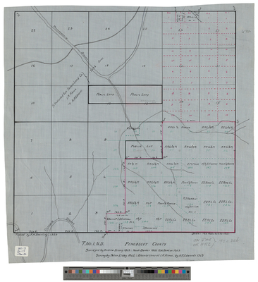
Maine State Archives
Document Type
StillImage
Identifier
4-361695-I092
Description
Summit (T1 ND) as surveyed by Andrew Strong in 1809, Noah Barker in 1868, Peter Libby in 1862, G.W. Banton in 1903, exterior lines by I.M. Pierce and H.R. Edwards in 1919.
Scale of 120 rods to 1 inch.
Exact Creation Date
1919
Language
English
Location
Penobscot County; Summit Twp
Other Location
Olamon Stream; Passadumkeag Stream; Fogg Brook
Keywords
Cartography; Maps; Surveys