

Preview
Contributing Institution
Maine State Archives
Document Type
StillImage
Identifier
4-308519-I009
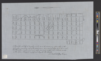
Description
Plan of Carroll Plantation, T6 R2 NBPP. Surveyed on a scale of 40 chains to 1 inch. Lots contain 160 acres each except where otherwise marked on the plan.
Exact Creation Date
7-1829
Language
English
Location
Penobscot County; Carroll Plt
Keywords
Cartography; Maps; Surveys