Home
Search
Browse State Agencies
My Account
About
Digital Commons Network™
Skip to main content
Home
About
FAQs
My Account
Home
>
StateDocs
>
Maine State Library (MSL)
>
MSL Special Collections
>
Elliotsville Plantation, Inc.
>
Elliotsville Plantation, Inc. Maps
Elliotsville Plantation, Inc. Map Collection
Printing is not supported at the primary Gallery Thumbnail page. Please first navigate to a specific Image before printing.
Follow
Switch View to List
View Slideshow
Natural Communities and Cultural Areas, Sandy Stream Sanctuary, T2R8 and T3R8 WELS, Maine, 2008
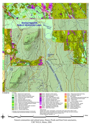
Natural Communities and Cultural Areas, Deasey Ponds and Hunt Farm Sanctuaries, T3R7 WELS, Maine, 2008
Natural Communities and Cultural Areas, East Branch Sanctuary, T5R8 WELS, Maine, 2008
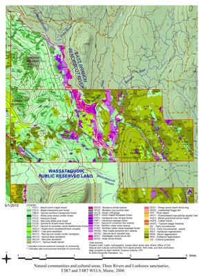
Natural Communities and Cultural Areas, Three Rivers and Lunksoos Sanctuaries, T3R7 and T4R& WELS, Maine, 2008, T5R8 WELS, Maine, 2008
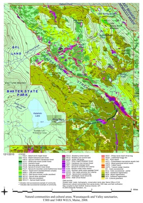
Natural Communities and Cultural Areas, Wassataquoik and Valley Sanctuaries, T3R8 and T4R8 WELS, Maine, 2008
Search
Enter search terms:
Select context to search:
in this collection
Digital Maine
Advanced Search
Notify me via email or
RSS
Browse
State Agencies
Subjects
Contributors
For Agency Contributors
FAQs
Featured Links
Maine Government
Maine State Library
Maine State Agencies
Digital Maine Partners
Gallery Locations
View gallery on map
View gallery in Google Earth


