

Preview
Document Type
StillImage
Contributing Institution
Maine State Archives
Identifier
BMC-11 p. 28 & 29
Description
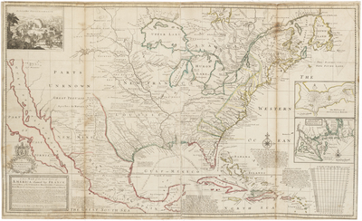
In 1720, London geographer and mapmaker, Herman Moll, published this map focusing on France's North American possessions. In a message below the title, he warned his British audience of French encroachment on neighboring English interests in the region and urged them to preserve old friendships with the Iroquois and Cherokees.
The depiction of the Southeast was based on recent English surveys, particularly those of Richard Berresford and Capt. Thomas Naime. However, the Southwest, where California is depicted as island, was based on outdated information that was mistakenly accepted by European mapmakers from the mid-17th century until the early 18th century.
Depths shown by soundings. Includes notes and illustration of "The Indian Fort Sasquesahanok." Insets: The harbour of Annapolis Royal -- A map of ye mouth of Mississipi [i.e. Mississippi] and Mobile Rivers
Broad Creation Date
1720
Dimensions
24.75" x 40.5"
Language
English
Keywords
Cartography; Maps