

Preview
Document Type
StillImage
Contributing Institution
Maine State Archives
Identifier
206947
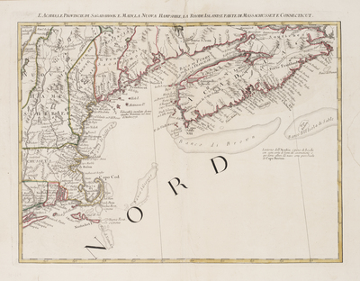
Description
Map of Acadia, the provinces of Sagadahoc and Maine, New Hampshire, Rhode Island and part of Massachusetts and Connecticut. Depicts the Northeastern coast, extending from the Hamptons on Long Island and the Connecticut River and showing all of New England, the Bay of Fundy and Acadia.
The map, while issued separately as part of Zatta's Atlante Novissimo, is one of 12 sections comprising the Italian edition of Mitchell's map of North America. John Mitchell's map of North America was one of the most important American maps of the 18th Century and is the foundation for virtually all boundary disputes and treaties beginning with the French & Indian War. It was drawn from the first available English and Indigenous surveys and includes detail regarding towns, roads, rivers, mountains and other regional features.
Broad Creation Date
1778
Dimensions
13" x 17"
Language
Italian
Other Location
New England
Keywords
Cartography; Maps