

Preview
Document Type
StillImage
Contributing Institution
Maine State Archives
Identifier
206944
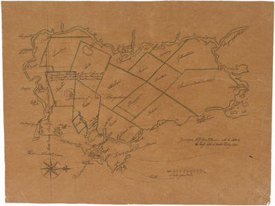
Description
Map of the Province of New Hampshire with note "rec'd from Col. Dunbar with his letter to the Sec'y dated at Boston 2 May 1730." Notes "Charter Division Line between the Provinces 3 miles N[orth] of the Meremack River."
David Dunbar (1728–1737) was a British military officer; as Surveyor of the King's Woods he made numerous enemies in his enforcement of regulations governing the cutting of trees that could be used as ship masts. He was the leader of an attempt to establish a colony named "Georgia" in what is now the central coast of Maine, and was in 1730 commissioned as lieutenant governor of the Province of New Hampshire in an attempt to strengthen his authority. He engaged in frequent disputes with New Hampshire's Governor Jonathan Belcher. He established Fort Frederick in Maine.
Exact Creation Date
6-5-1730
Language
English
Location
York County
Other Location
New Hampshire; Province of Maine; Massachusetts; Merrimack River
Keywords
Cartography; Maps