

Preview
Document Type
StillImage
Contributing Institution
Maine State Archives
Identifier
206851
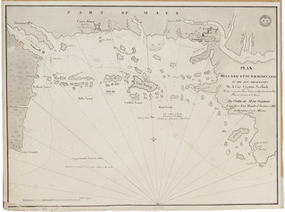
Description
Title translation: Plan of Casco Bay and Harbour and adjacent islands, by Cyprian Southack. Written, according to an English map, general deposit maps, plans and navy newspapers. By order of Sartine, state councilor, Minister and Secretary of State at the Department of the Navy.
Nautical chart of Casco Bay and surrounding settlements including Casco Fort. Depths shown by soundings. Captain Cyprian Southack (1662-1745) explored Portland harbor in 1698 and published his chart in London in 1720. It appeared, with minor modifications, in many editions of The English Pilot between 1721 and the 1790s. Here it has been appropriated by the French, where it appeared in Neptune Americo-Septentrionale at the time of the American Revolution. By the time this French version appeared, the British had vastly superior charts of Casco Bay that were included in The Atlantic Neptune.
Broad Creation Date
1779
Dimensions
16" x 22"
Language
French
Location
Cumberland County
Other Location
Casco Bay, Maine
Keywords
Cartography; Maps; Harbors