

Preview
Document Type
StillImage
Contributing Institution
Maine State Archives
Identifier
206849
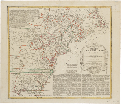
Description
This map depicts the British and French colonies at the onset of the French and Indian War. The War began in 1754, but it was not until 1756 that England declared war against France. The latest information from western Virginia (i.e., the Ohio Valley) has been included.
The French forts in Ohio, which were defended from Braddock and Washington in 1754, are marked. Walker's Settlement of 1750 is also noted. The colonial boundaries are shown extending out beyond the Mississippi, with New England's claims reaching into Manitoba.
Broad Creation Date
circa 1756
Language
English; German
Keywords
Cartography; Maps