

Preview
Document Type
StillImage
Contributing Institution
Maine State Archives
Identifier
BMC-44 p.89
Description
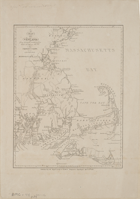
A map of Vinland : from accounts contained in Old Northern MSS by Charles C. Rafn ; P. Seehusen sc. Copenhagen : Royal Society of Northern Antiquaries, 1837.
This is a map of Massachusetts Bay and parts of New England. This map depicts early Norse exploration and is created from descriptions by Norse travelers in New England.
Broad Creation Date
1837
Dimensions
14" x 10"
Language
English
Keywords
Cartography; Maps