


Files
Download Full Text (2.6 MB)
Contributing Institution
Maine State Archives
Document Type
Text
Exact Creation Date
6-5-1855
Language
English
Recommended Citation
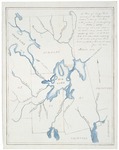
"John Gardner’s Survey Map of Nemcass Point (or Governor’s Point) on Big Lake (watercolor), containing 100 acres for the Passamaquoddy Tribe" (1855). Choosing Survival: Wabanaki Documents at the Maine State Archives. 6.
https://digitalmaine.com/acr_choosing_survival/6
Rights Statement

No Copyright - United States. URI: http://rightsstatements.org/vocab/NoC-US/1.0/
The organization that has made the Item available believes that the Item is in the Public Domain under the laws of the United States, but a determination was not made as to its copyright status under the copyright laws of other countries. The Item may not be in the Public Domain under the laws of other countries. Please refer to the organization that has made the Item available for more information.
Description
In the 1794 treaty with Massachusetts, the Passamaquoddy retained rights to 100 acres at Nemcass Point (or Governor’s Point), a peninsula on Big Lake in Hinkley Township, situated west of Indian Township. As landowners bought and sold portions of this township, a land deed omitted an exclusionary clause about the tribal land, leading to a land dispute. After Passamaquoddy leaders petitioned Maine to assert their rights to Nemcass Point, surveyor John Gardner produced this 1855 map delineating the property line separating tribal and private lands. Chief Peol Tomah farmed Nemcass Point and withstood harassment from adjacent settlers who wanted the land. However, after decades of farming the point, Tomah’s death in 1890 resulted in Nemcass Point being sold. [Description Text by Micah A. Pawling, Ph.D]