

Preview
Document Type
StillImage
Contributing Institution
Prince Memorial Library
Description
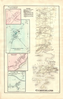
Map of Cumberland, Maine, digitized from plate 51 of F. W. Beers' Atlas of Cumberland County, Maine, 1871. Published by F. W. Beers of New York, 1871. Shows businesses, industries, cemeteries, dwellings and property owners' names in Cumberland, Maine, in 1871. Includes insets of Cumberland Center and Poland Corners, as well as New Casco and Presumpscot Falls of the Town of Falmouth. Scale [1:5400] 450 ft. = 1 in.
Exact Creation Date
1871
Dimensions
37 cm x 60 cm
Language
English
Location
Cumberland County; Cumberland
Keywords
Cumberland; Maine; Maps