

Preview
Document Type
StillImage
Contributing Institution
Maine State Archives
Identifier
208369
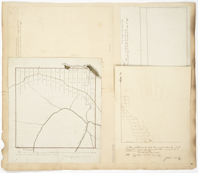
Description
Page 3 consists of 4 maps to one page, which have been scanned as Page 03 and 03A. Surveys done in 1840 and 1844 on a scale of 40 chains to an inch.
Broad Creation Date
1840; 1844
Language
English
Location
Aroostook County; T15 R6 WELS
Other Location
Fish River; Presque Isle River; Aroostook River
Keywords
Cartography; Maps; Maine Land Office; Planbooks; Surveys
Image Location
Rights Statement
No Copyright - United States. URI: http://rightsstatements.org/vocab/NoC-US/1.0/
The organization that has made the Item available believes that the Item is in the Public Domain under the laws of the United States, but a determination was not made as to its copyright status under the copyright laws of other countries. The Item may not be in the Public Domain under the laws of other countries. Please refer to the organization that has made the Item available for more information.