

Preview
Document Type
StillImage
Contributing Institution
Maine State Archives
Identifier
207608
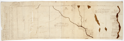
Description
Plan delineating the boundaries of three townships together with the Settlers Lots therein being numbers one, two and three in the Second Division of Townships Northward of the Plymouth Companies Land on the West side Kennebec River. Includes front and back of page.
Scale 200 rods to one inch.
Exact Creation Date
1790
Language
English
Location
Somerset County; Embden
Keywords
Cartography; Maps; Maine Land Office; Planbooks; Surveys
Image Location
Rights Statement
No Copyright - United States. URI: http://rightsstatements.org/vocab/NoC-US/1.0/
The organization that has made the Item available believes that the Item is in the Public Domain under the laws of the United States, but a determination was not made as to its copyright status under the copyright laws of other countries. The Item may not be in the Public Domain under the laws of other countries. Please refer to the organization that has made the Item available for more information.