


Files
Document Type
StillImage
Description
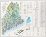
Maine Geological Survey. Wall map showing the surficial geology of Maine. Includes sites of special interest, radiocarbon-dated sites, reference list, correlation chart, inset map of inferred extent of ice cover during deglaciation.
Publication Code
SGMM
Publication Date
1-1-1985
Publisher
Maine Geological Survey
Supercedes
84-2
Location
Androscoggin County; Aroostook County; Cumberland County; Franklin County; Hancock County; Kennebec County; Knox County; Lincoln County; Oxford County; Penobscot County; Piscataquis County; Sagadahoc County; Somerset County; Waldo County; Washington County; York County
Map Type
Geologic Maps of the State of Maine; Surficial Geology Regional Maps
Map Scale
1:500000
Recommended Citation
Thompson, Woodrow B., and Borns, Harold W., Jr. (editors), 1985, Surficial geologic map of Maine: Maine Geological Survey, 42" x 52" color map, scale 1:500,000. Maine Geological Survey Maps. 15. http://digitalmaine.com/mgs_maps/15
Rights Statement

No Copyright - United States. URI: http://rightsstatements.org/vocab/NoC-US/1.0/
The organization that has made the Item available believes that the Item is in the Public Domain under the laws of the United States, but a determination was not made as to its copyright status under the copyright laws of other countries. The Item may not be in the Public Domain under the laws of other countries. Please refer to the organization that has made the Item available for more information.