

Preview
Contributing Institution
Scarborough Historical Society
Document Type
Image
Identifier
SHS-Maine-Surnames-Auger
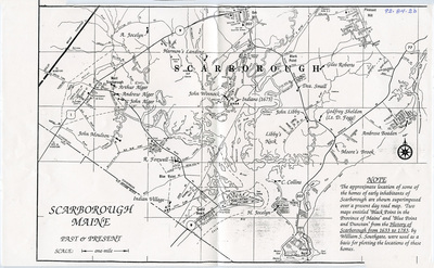
Description
The approximate locations of some of the homes of early inhabitants of Scarborough are shown superimposed over a present-day roadmap. Two maps entitled “Black Point in the Province of Maine” and “Blue Point and Dunstan” from the History of Scarborough from 1633 to 1783 by William S. Southgate were used as a basis for plotting the locations of these home:
Homesteads Identified include the following:
Alger, Arthur
Alger, Andrew
Alger, John
Boaden, Ambrose
Collins, C.
Fogg, Lt. D.
Foxwell, R.
Harmon’s Landing
Jocelyn, A.
Jocelyn, H.
Libby, John
Moore’s Brook
Moulton, John
Roberts, Giles
Sheldon, Godfrey
Small, Dea.
Winnock, John
Broad Creation Date
ca. 1990
Location
Cumberland County; Scarborough
Keywords
Homestead, Families,