

Preview
Document Type
StillImage
Contributing Institution
Maine State Archives
Identifier
209714
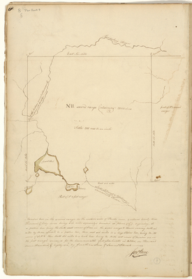
Description
Plan of T2 R2 (Hermon) in Penobscot County on the western side of Penobscot River. Surveyed for the Commonwealth of Massachusetts October 1786. Scale of 200 rods to 1 inch.
Exact Creation Date
10-1786
Language
English
Location
Penobscot County; Hermon
Other Location
Kenduskeag Stream; Great Pond; Patersons Pond; Souadabscook Stream
Keywords
Cartography; Maps; Maine Land Office; Planbooks; Surveys