

Preview
Document Type
StillImage
Contributing Institution
Maine State Archives
Identifier
209714
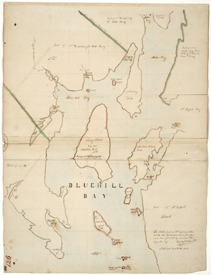
Description
Survey of islands in Blue Hill Bay and part of Mt. Desert on a scale of 200 rods to an inch.
Exact Creation Date
1785
Language
English
Location
Hancock County; Blue Hill; Mount Desert
Other Location
Beach Island; Moose Island; Robertsons Island; Channel Rock; Herrick's Bay; Naskege Point; Long Island
Keywords
Cartography; Maps; Maine Land Office; Planbooks; Surveys