

Preview
Contributing Institution
Maine State Archives
Document Type
StillImage
Identifier
4-308519-I001
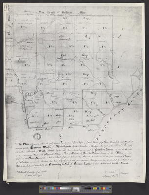
Description
This plan represents within the red lines twenty one townships of land between the rivers Kennebeck and Penobscot surveyed for the Commonwealth of Massachusetts by the subscribers A.D. 1792. Also part of the River Penobscot; the northern Bounds of Waldo Patent; Together with Four Townships surveyed by Jonathan Stone, as also the Bounds of the northesterly Part of the Plymouth Claim, Part of Sebasticook River, the Southeast Corner of the Million Acres located on the River Kennebeck, and a tract of land betwixt the Plymouth Claim etc. and the four northerly Ranges of Townships aforesaid; All which has been taken from actual and approved Surveys and here protracted by a scale of two miles to an Inch, and inscribed to the Committee for Sale of Eastern Lands by their obedient and humble servants.
Copy of Planbook 6, Page 12.
Exact Creation Date
10-20-1792
Language
English
Location
Penobscot County
Keywords
Cartography; Maps; Surveys