

Preview
Document Type
StillImage
Contributing Institution
Prince Memorial Library
Description
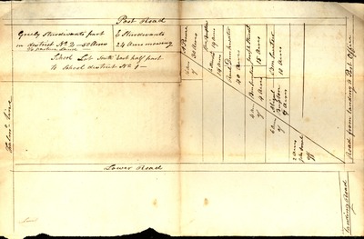
A Rough Plan of the Most Easterly Line of School District No. 2 shows the area of Cumberland Foreside bordered by the Falmouth town line on the southwest, Post Road (now Middle Road) on the northwest, the “Road from landing to Post Office” (now Tuttle Road) on the northeast, and Lower Road (now Foreside Road) on the southeast. Landing Road (now Town Landing Road) is also shown. The map displays the property owners on the southeast side of Post Road and the amount of acreage for each, including Greely Sturdivant, Ephraim Sturdivant, A. Prince, William Buxton, Reuel Drinkwater, Ben Sweetser, Joseph Sturdivant, and Abigail Buxton. John Small is the only property owner shown for the northwest side of Lower Road. The date of 1836 is not part of the title of the map, but is in pencil in another hand and seems to have been added at some point after the map was created.
Broad Creation Date
ca. 1836
Dimensions
21 cm. x 32 cm.
Language
English
Location
Cumberland County
Keywords
School Districts; Cumberland; Maine; Landowners
Rights Statement
No Copyright - United States. URI: http://rightsstatements.org/vocab/NoC-US/1.0/
The organization that has made the Item available believes that the Item is in the Public Domain under the laws of the United States, but a determination was not made as to its copyright status under the copyright laws of other countries. The Item may not be in the Public Domain under the laws of other countries. Please refer to the organization that has made the Item available for more information.