

Preview
Contributing Institution
Maine State Archives
Document Type
StillImage
Identifier
302964
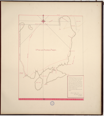
Description
Page 17 of the Waldo County planbook copied from the Massachusetts Archives Maps and Plans #1335.
"This plot describeth an accurate plan of the Town of Prospect acording to the act of the general Court on June the 18th 1794. Laid down by a Scale of two hundred Rods to an Inch. The Distance from the Centre of the town to the Shire town in the County is suppos'd to be fifteen Miles by the County Road, & Two Hundred & thirty miles from Boston."
Exact Creation Date
5-1795
Language
English
Location
Waldo County; Prospect
Other Location
Fort Point; Cape Jellison; Sandy Point; Penobscot River; Gundalow Cove; Brigadier Island; Halfway Creek; Belfast; Goose Pond; Moon Pond
Keywords
Cartography; Maps; Maine Land Office; Planbooks; Surveys
Image Location
Rights Statement
No Copyright - United States. URI: http://rightsstatements.org/vocab/NoC-US/1.0/
The organization that has made the Item available believes that the Item is in the Public Domain under the laws of the United States, but a determination was not made as to its copyright status under the copyright laws of other countries. The Item may not be in the Public Domain under the laws of other countries. Please refer to the organization that has made the Item available for more information.