

Preview
Contributing Institution
Maine State Archives
Document Type
StillImage
Identifier
302964
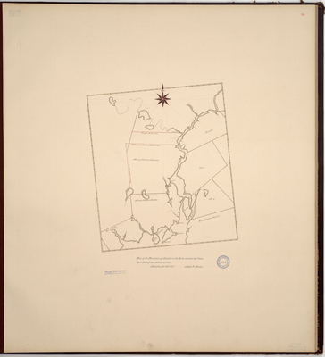
Description
Page 16 of the Waldo County planbook. Survey of the town of Frankfort and Prospect on a scale of two miles to an inch. Includes Fort Pownal, Cape Jellison, Sandy Point, Brigadier's Island, Cape Jellison Harbor, Penobscot Township, Eastern River, Orphan's Island, Marsh River, Half Moon Pond, Goose Pond, Orrington, and Wheelersburgh Plantation.
Copied from Massachusetts Archives Maps and Plans #985. Notation on map "from papers Act of Incorporation, Prospect, Feb. 24, 1791."
Exact Creation Date
12-30-1791
Language
English
Location
Waldo County; Prospect; Frankfort
Keywords
Cartography; Maps; Maine Land Office; Planbooks; Surveys
Image Location
Rights Statement
No Copyright - United States. URI: http://rightsstatements.org/vocab/NoC-US/1.0/
The organization that has made the Item available believes that the Item is in the Public Domain under the laws of the United States, but a determination was not made as to its copyright status under the copyright laws of other countries. The Item may not be in the Public Domain under the laws of other countries. Please refer to the organization that has made the Item available for more information.