

Preview
Contributing Institution
Maine State Archives
Document Type
StillImage
Identifier
302962
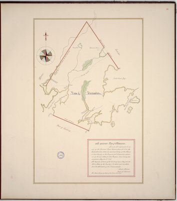
Description
Page 11 of the Knox County planbook. Copied from the Massachusetts Archives Maps and Plans #1378.
"Agreeable to an act of the General Court Passed June 26th, 1794, we Subscribers have taken an accurate Survey of the Town of in Said County at the Request of A Committee appointed by the said Town for that Purpose. Said Survey was completed May the 4th, 1795. The Reputed Distance of the Centre of said Town from the Shire Town of the County is 37 Miles and 209 Miles from the Metropolis of the Commonwealth. This Plan is Drawn by Scale of 200 Rods to an inch."
Exact Creation Date
5-4-1795
Language
English
Location
Knox County; Thomaston; South Thomaston; Owls Head; Lincoln County
Other Location
Wassawasgig Great Marsh; Wassawasgig River; Ash Point Island; Sheep Island; Georges River; Georges Bay; Tolemans Pond; Madambelix Mount; Muddy Pond; Great Meadow
Keywords
Cartography; Maps; Maine Land Office; Planbooks; Surveys
Image Location
Rights Statement
No Copyright - United States. URI: http://rightsstatements.org/vocab/NoC-US/1.0/
The organization that has made the Item available believes that the Item is in the Public Domain under the laws of the United States, but a determination was not made as to its copyright status under the copyright laws of other countries. The Item may not be in the Public Domain under the laws of other countries. Please refer to the organization that has made the Item available for more information.