

Preview
Contributing Institution
Maine State Archives
Document Type
StillImage
Identifier
29424
Description
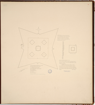
Page 20 of the Kennebec County planbook. Diagram of Fort Halifax at mouth of Kennebec and Sebasticook Rivers. At the time of the diagram, it was British colonial outpost in Winslow, Maine. It was built as a wooden palisade fort in 1754, during the French and Indian War.
Copied from Massachusetts Archives Maps and Plans #708. Notation on map "from Archives Vol 74 Page 471, Fort Halifax 1754."
Exact Creation Date
10-4-1754
Language
English
Location
Kennebec County; Winslow
Keywords
Cartography; Maps; Maine Land Office; Planbooks; Surveys