

Preview
Document Type
StillImage
Contributing Institution
Maine State Archives
Identifier
209714
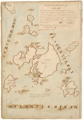
Description
Survey of Swans Island area bordered by Jericho Bay, Placentia Bay, and the Atlantic Ocean. Surveyed for the Commonwealth of Massachusetts in September and October 1785 on a scale of 200 rods to 1 inch. Attested by Rufus Putnam.
Exact Creation Date
10-1785
Language
English
Location
Hancock County; Swans Island
Other Location
Jericho Bay; Placentia Bay; Atlantic Ocean; Marshalls Island; Long Island; Burntcoat Island; Seal Bay; Naskeag; Pond Island; Eastern and Western Calf Islands
Keywords
Cartography; Maps; Maine Land Office; Planbooks; Surveys