

Preview
Document Type
StillImage
Contributing Institution
Maine State Archives
Identifier
209685
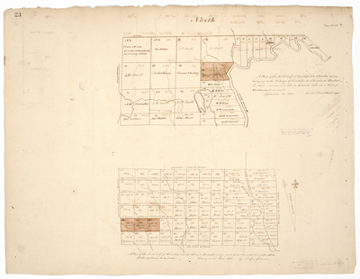
Description
Map 1: A plan of the south half of Township No. 1, Titcomb's survey belonging to the 2nd Range of Townships North of Bingham's Penobscot Purchase, as run into lots in September 1832 on a scale of 40 chains to an inch. September 23, 1832, Caleb Leavitt, Surveyor.
Map 2: A plan of the North half of Township number three in the sixth range west from the east line of the State. Scale 40 chains to an inch. Surveyed in June 1832 by Rufus Gilmore.
Exact Creation Date
1832
Language
English
Location
Washington County; Lambert Lake Twp; Penobscot County; Stacyville
Other Location
Aroostook Road; Moluncus; Molunkus; St. Croix River; Tomah Stream
Keywords
Cartography; Maps; Maine Land Office; Planbooks; Surveys