

Preview
Document Type
StillImage
Contributing Institution
Maine State Archives
Identifier
209685
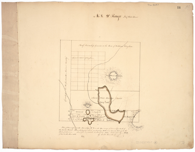
Description
Survey of land in Elliotsville Plantation (T8 R9) in Piscataquis County on a scale of 2 inches to one mile. Includes boundaries with land granted to the Massachusetts Medical Society, the Saco Free Bridge land, and half of the township granted to the heirs of William Vaughan.
Exact Creation Date
10-1830
Language
English
Location
Elliottsville Twp; Piscataquis County
Other Location
Ship Pond; Willamantic
Keywords
Cartography; Maps; Maine Land Office; Planbooks; Surveys