

Preview
Document Type
StillImage
Contributing Institution
Maine State Archives
Identifier
209948
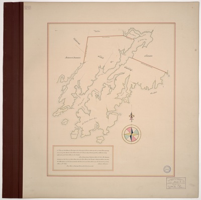
Description
Page 2. Plan of Cushing, Lincoln County, pursuant to an act of the General Court passed June 26, 1794. Surveyed by James Malcom. Scale of 200 rods to 1 inch. Copied from original #1353 Maps and Plans, MA Archives.
Exact Creation Date
4-11-1795
Language
English
Location
Knox County; Cushing
Other Location
Madumcook Plantation; Meduncook Plantation; Moschetto Island; Mosquito Island; Thomaston; Smith's Cove; Broad Cove; Madumcook River; St. George's River; St. George's Lower Neck; Maplejuice Cove; Gaunt Neck Cove; Caldwell Island; Gaye Island; Herring Gut; Talants Harbour; Tenant's Harbor; Smith's Island; Long Cove; Cutler's Cove; Wattsons Point; Warren; Waldoborough; Waldoboro; Old Fort Point; St. George's Bay
Keywords
Maine Land Office; Maps; Planbook; Survey
Rights Statement
No Copyright - United States. URI: http://rightsstatements.org/vocab/NoC-US/1.0/
The organization that has made the Item available believes that the Item is in the Public Domain under the laws of the United States, but a determination was not made as to its copyright status under the copyright laws of other countries. The Item may not be in the Public Domain under the laws of other countries. Please refer to the organization that has made the Item available for more information.