

Files
Download Full Text (15.0 MB)
Document Type
StillImage
Contributing Institution
Prince Memorial Library
Publication Date
9-2016
Language
English
Recommended Citation
Topographix LLC, "Plan of Farris Cemetery, Blanchard Road and Bruce Hill Road, Cumberland, Maine, 2016" (2016). Town of Cumberland Plans. 473.
https://digitalmaine.com/cumberland_plans/473
Rights Statement

No Copyright - United States. URI: http://rightsstatements.org/vocab/NoC-US/1.0/
The organization that has made the Item available believes that the Item is in the Public Domain under the laws of the United States, but a determination was not made as to its copyright status under the copyright laws of other countries. The Item may not be in the Public Domain under the laws of other countries. Please refer to the organization that has made the Item available for more information.
Description
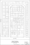
Plan of Farris Cemetery, Blanchard Road and Bruce Hill Road, Cumberland, Maine was revised and computerized by Topographix in January 2010, and revised in September 2016. Originated November 23, 1934, by S. S. Lowe and H. H. Sweetser, engineers. Scale 1” = 10’.