

Preview
Document Type
StillImage
Contributing Institution
Maine State Archives
Identifier
206949
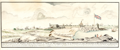
Description
Ink and watercolor drawing shows Fort William and Mary on the Piscataqua River with surrounding landscape and buildings in "the town of New Castle on the Great Island." Many features are identified by letter with corresponding key, including the powder house, minister's house, and the "newly made block house and dungeon." Also shows a large, not to scale, British flag on "the new flag staff" at the fort. Signed by Captain Cyprian Southack, Commander.
The original map is in the British Library with this description: "View of Fort William and Mary (Fort Constitution) from the South, with three men in conversation at right in the foreground, town of New Castle at left, fort in the middle with British flag flying above, and English ship sailing on Piscataqua River at right in the background, with Maine seen in distance beyond; key and explanatory text below, within washline." http://explore.bl.uk/BLVU1:LSCOP-ALL:BLL01004987813
Broad Creation Date
1705
Dimensions
9" x 23"
Language
English
Other Location
New Hampshire
Keywords
Cartography; Maps; British Colonies