

Preview
Document Type
StillImage
Contributing Institution
Maine State Archives
Identifier
206948
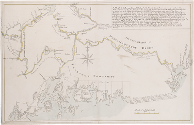
Description
Map of Penobscot Bay, Penobscot River, Passamaquoddy River to the St. Croix surveyed by order of Governor Francis Bernard of Massachusetts. Includes area from Muscongus Bay to Deer Isle and Cobscook Bay and the islands of Isle Au Haut, Burnt Coat, Mount Desert, and Fox Islands (Vinalhaven and North Haven). Notes the route of Lieutenant Montresor between Quebec and Fort Halifax in 1761, and a "Road for Foot Men Only over Megunticook Mountain."
Broad Creation Date
1764
Language
English
Other Location
Penobscot Bay
Keywords
Cartography; Maps; Province of Maine