

Preview
Document Type
StillImage
Contributing Institution
Maine State Archives
Identifier
BMC-4 p.15
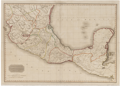
Description
Spanish dominions in North America, middle part. Drawn under the direction of Mr. Pinkerton by L. Hebert. Neele sculpt. 352 Strand. London: published by Cadell & Davies, Strand & Longman, Hurst, Rees, Orme, & Brown, Paternoster Row.
Engraved map. Shows mines, farms, shoals, etc. Relief shown by hachures. Covers central and southern Mexico, Belize, Guatemala, El Salvador and part of Honduras. This map was published in Pinkerton’s Modern Atlas in September 1811.
Exact Creation Date
9-11-1811
Dimensions
20.5"x 28.5"
Language
English
Other Location
Mexico; Central America
Keywords
Cartography; Maps