

Preview
Document Type
StillImage
Contributing Institution
Maine State Archives
Identifier
206758
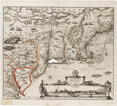
Description
Second state of Danckerts’ map of New Netherlands, including a view of New Amsterdam, now also called "Nieuw Yorck." Includes inset view of the Dutch colony on Manhattan Island.
The cartographic information is based upon Jansson's map of 1650. This map was issued about 1684 and shows Philadelphia for the first time, as well as adding farm animals. It also shows the Battery and Dutch buildings on the waterfront. The Delaware River is completely revised so that it no longer connects with the Hudson River. Pennsylvania is named; its boundary is marked.
The addition of domesticated farm animals in the New Netherlands colony is of historical note. The Dutch colonists were, by the 1680s, increasingly disillusioned with the support they were receiving from Holland. A delegation was sent to Den Haag to appeal for more support, money, settlers, etc. One of the by-products of the colonist's meeting / plea was the revision of this map as a propaganda tool, displaying farm animals in New England in order to entice prospective new colonists to emigrate, on the theory that life in the New World was similar to life in Holland.
Broad Creation Date
1684
Dimensions
22” x 18.5”
Language
Dutch
Keywords
Cartography; Maps