

Preview
Document Type
StillImage
Contributing Institution
Maine State Archives
Identifier
206944
Description
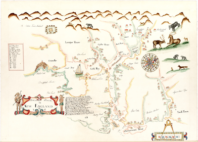
The surveyor who drew the original map is unknown, except for his initials "J. S." The map is undated.
The first letter of each line of verse just to the right of the map's title, when read vertically from top to bottom, spells out "James Duke of York." The map was therefore made sometime between 1660 and 1685, during the reign of Charles II of England, when his younger brother James held the title of Duke of York.
The surveyor was trying to flatter the duke:
Just Great and Good are Princely epithets
And each of these your highness well befitts
My aime with your great virtues cannot want
Encouragement (craving what's fit to grant)
Serenest Prince I heer (unto your eye)
Declare (by mapp) how England's strength doth lye
Unseen in rivers of the New Plantations
Kingly commanding heads of other nations
Equally it to honor neither Spain
Or the boasting Dutch can shew the like againe!
Freely accept (Great Sire) the loyaltie
Your meanest servant offers to your eye
Oceans and rivers ring loud peales of faime
Resounding echoes to your honor'd name
Kind heav'ns and stars continue long the same.
Broad Creation Date
circa 1670
Dimensions
40" x 54"
Language
English
Location
York County; York
Other Location
New Hampshire; Piscataqua River
Keywords
Cartography; Maps; Province of Maine