

Preview
Document Type
StillImage
Contributing Institution
Maine State Archives
Identifier
206949
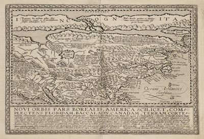
Description
Map of North America, derived from Cornelis de Jode's 1593 Americae Pars Borealis. This map depicts all of North America from the unexplored Arctic to the Gulf of Mexico and from the Pacific to the Atlantic. The map predates the exploration of Samuel de Champlain but draws upon those of Jacques Cartier, Sebastian Cabot, Giovanni Verrazano, Sir Walter Raleigh, John White and Jacques Le Moyne.
A long narrow waterway to the north represents the North West Passage. Some place names have been left out, including the settlements of Bermuda, St. Augustine, Roanoke,and Chesapeake. A second peninsula is shown to the west of Florida.
Broad Creation Date
1585
Dimensions
8.5" x 12.5"
Language
Latin
Other Location
North America
Keywords
Cartography; Maps