

Preview
Document Type
StillImage
Contributing Institution
Maine State Archives
Identifier
BMC-16 p.41
Description
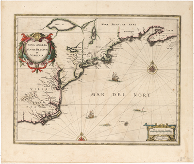
Map of the East Coast of North America, from the Carolinas to Nova Scotia.
Jansson based his map upon Johannes De Laet’s map of 1630 (created and engraved by Hessel Gerritsz of the Dutch East India Company), which is generally regarded as the source map for New England and the Northeast, being the first to name in any form Manhattan, New Amsterdam, the North River (Hudson) and South River (Delaware), along with the first appearance of Massachusetts (and the recently established English Colony therein). The two maps provided the best representation to date of the coastline, and are among the earliest printed maps to document English settlement in New England and Dutch settlement along the Hudson River.
Jansson did not include the updated cartography provided by Champlain’s map. This is also an early map to identify any part of the Great Lakes, with Grand Lac and Lac des Yroquois (Ontario or Erie) depicted. The only European settlement shown in New England is Plymouth, established in 1620. Further south shows the Dutch settlements of New Amsterdam (New York City) and Fort Orange (Albany).
Published in Mercator's 1639 Nouvel Atlas.
Broad Creation Date
ca. 1639
Dimensions
21"x 24.75"
Language
Latin
Keywords
Cartography; Maps; North America; Virginia