

Preview
Contributing Institution
Maine State Archives
Document Type
StillImage
Identifier
29424
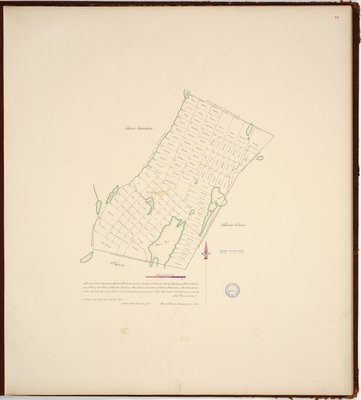
Description
Page 19 of the Kennebec County planbook. Survey of what is now the town of Vienna on a scale of 160 rods to one inch. Red lines indicate roads most traveled.
Exact Creation Date
1-6-1802
Language
English
Location
Kennebec County; Vienna
Other Location
Parkers Pond; Perrys Pond; Girdes Pond; Little Norrigewalk Stream; Fayette; Flying Pond
Keywords
Cartography; Maps; Maine Land Office; Planbooks; Surveys