

Preview
Document Type
StillImage
Contributing Institution
Maine State Archives
Identifier
209714
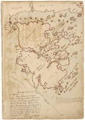
Description
Plan of the Deer Isle Division. Surveyed for the Commonwealth in October and November 1785. Scale of 200 rods to 1 inch.
Exact Creation Date
11-1785
Language
English
Location
Hancock County; Deer Isle
Other Location
Isle of Holt; Moose Island; Crotch Island; Sheep Island; Greenlow's Neck; Southeast Harbor; Eggemoggin Reach; Naskege Point; Naskeag; Brooklin
Keywords
Cartography; Maps; Maine Land Office; Planbooks; Surveys