

Preview
Document Type
StillImage
Contributing Institution
Maine State Archives
Identifier
209714
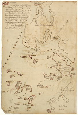
Description
Plan of Little Deer Isle, bounded on the west by Penobscot Bay and north by Eggemoggin Reach. Surveyed for the Commonwealth of Massachusetts in October and November 1785. Scale of 200 rods to 1 inch.
Exact Creation Date
11-1785
Language
English
Location
Hancock County; Deer Isle
Other Location
Penobscot Bay; Eggemoggin Reach; Major Bagaduce Harbor; Major Bagaduce Neck; Cape Rosa [Rosier]; Buck Harbor; Tent Island; Hog Island; Western Island; Pond Island; Burnt Island; Head Island; Eaton's Island; Pickering's Island; Stave Island; Bradbury's Island; Hardhead Island; Dunham's Point; Ragged Head; Northwest Harbor; Sheep Island; Oak Island; Hooper Ledge; Eagle Island; Sloop Island; Bear Island; Compass Island; Great Spruce Head Island; Fling Island
Keywords
Cartography; Maps; Maine Land Office; Planbooks; Surveys