

Preview
Document Type
StillImage
Contributing Institution
Maine State Archives
Identifier
208257
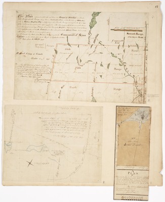
Description
Plan represents within the red lines, two Ranges of Townships numbered Fifth and Sixth Range lying between Newhamshire Line [New Hampshire] and the West line of Million Acres sold to William Bingham Esq. and adjoining on the Fourth Range surveyed in the Year 1794
Plan of Lot 5 in the first Division of Land laid out in Township 12 on the south branch of Cobscook Bay, containing 200 Acres as laid out to Samuel Trescott, including his improvements, by order of the Agents of this Commonwealth (1804)
Plan of the Dummer Academy Grant (1799). Includes part of lands laid out to John Crane and George Peck
Broad Creation Date
1794-1804
Language
English
Location
Washington County
Other Location
Androscoggin River; Chaudiere River
Keywords
Cartography; Maps; Maine Land Office; Planbooks; Surveys
Rights Statement
No Copyright - United States. URI: http://rightsstatements.org/vocab/NoC-US/1.0/
The organization that has made the Item available believes that the Item is in the Public Domain under the laws of the United States, but a determination was not made as to its copyright status under the copyright laws of other countries. The Item may not be in the Public Domain under the laws of other countries. Please refer to the organization that has made the Item available for more information.