

Preview
Document Type
StillImage
Contributing Institution
Maine State Archives
Identifier
210848
Description
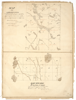
Map of Part of the Undivided Lands - Townships 5-8, Ranges 11-13 west from the east line of the State. Surveyed by order of the land agents of Massachusetts and Maine. Scale of 100 chains to an inch.
Map of half of Township B, Range 1 WELS. Surveyed by direction of George W. Coffin Esq. Land Agent of Massachusetts. Variation 16 degrees-50' W. Scale of 40 chains to an inch.
Broad Creation Date
1840-1842
Language
English
Location
Aroostook County; Blaine; Piscataquis County; T5 R12 WELS; T7 R11 WELS; T7 R12 WELS; T7 R13 WELS; T8 R11 WELS; T6 R11 WELS; T6 R12 WELS; T6 R13 WELS
Other Location
Chesuncook Lake; Penobscot River; Telos Lake; Allagash Stream; Mars Hill
Keywords
Cartography; Maps; Maine Land Office; Planbooks; Surveys
Rights Statement
No Copyright - United States. URI: http://rightsstatements.org/vocab/NoC-US/1.0/
The organization that has made the Item available believes that the Item is in the Public Domain under the laws of the United States, but a determination was not made as to its copyright status under the copyright laws of other countries. The Item may not be in the Public Domain under the laws of other countries. Please refer to the organization that has made the Item available for more information.