


Preview
Contributing Institution
Maine Geological Survey
Document Type
Image
Identifier
11599
Description
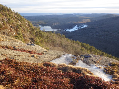
This view to the south along the valley between Bald and Ragged mountains looks across the former marine limit following the last glacial recession. The marine limit was just above Hosmer Pond, so most of the lowland in this view was below sea level, except for two small islands at Beech Hill (with small stand of pines in the middle distance), and Dodge Mtn to the west (right) of Rockland. Bald mountain and Ragged Mountain were on the south side of a large offshore island.
Project Name: Bald Mountain, Camden
Exact Creation Date
12-16-2019
Location
Camden
Supplemental Rights
Credit must be given to the photographer and the Maine Geological Survey when this photo is displayed, reproduced, distributed and/or used in derivative works.
Keywords
marine limit; highstand; ice age; sea level