

Preview
Document Type
StillImage
Contributing Institution
Maine State Archives
Identifier
209714
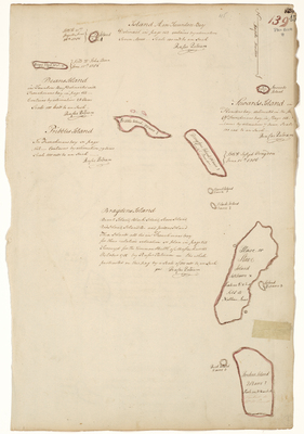
Description
"Bragdon's Island, Burnt Island, Black Island, Slave Island, Red Island, Island B, and Jordens Island. These Islands all lie in Frenchman's Bay for their relative situation see plan in page 142. Survey'd for the Commonwealth of Massachusetts October 1785 by Rufus Putnam - the whole protracted on this page by a scale of 100 rods to an inch."
Also includes surveys of Island A and Beans Island in Taunton Bay, Sowards Island in Flanders Bay, and Pribbles Island in Frenchman's Bay.
Taunton Bay is a shallow estuary linking the towns of Hancock, Sullivan and Franklin in Hancock County.
Exact Creation Date
1785
Language
English
Location
Hancock County
Keywords
Cartography; Maps; Maine Land Office; Planbooks; Surveys