

Preview
Document Type
StillImage
Contributing Institution
Maine State Archives
Identifier
209714
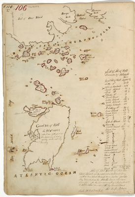
Description
Isle Au Haut. These islands are bounded west on Fox Island Bay, north on Deer Island Thoroughfare, East on Jericho Bay and south on the Atlantic Ocean and were surveyed for the Commonwealth of Massachusetts in October and November 1785. Scale of 200 rods to 1 inch.
Exact Creation Date
11-1785
Language
English
Location
Knox County; Isle Au Haut
Other Location
Great Isle Au Haut; Little Isle Au Haut; White Island; Burnt Island; Sheep Island; Flake Island; Birch Point; Webb's Island; York Island; Spoon Islands; McGlathery's Island; Bear Island; Crotch Island; Island (Poor); Camp Island; Indian Island; Ash or Saddleback Island; Mark Island; Stevenson's Neck; Southeast Harbor
Keywords
Cartography; Maps; Maine Land Office; Planbooks; Surveys