

Preview
Document Type
StillImage
Contributing Institution
Maine State Archives
Identifier
209714
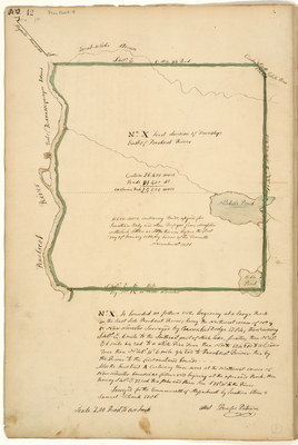
Description
Plan of Bradley and Eddington area containing 26,400 acres. Adjacent to east side of Penobscot River and New Worcester surveyed by Barnabas Dodge in 1784. Surveyed for the Commonwealth of Massachusetts in 1786.
Includes notation "11,660 acres, including Ponds, assigned for Jonathan Eddy and other Refugees from Nova Scotia with such Settlers as Settled thereon before the first day of January 1784, by order of the Committee. November 16th, 1786.
Exact Creation Date
1786
Language
English
Location
Penobscot County; Bradley; Eddington
Keywords
Cartography; Maps; Maine Land Office; Planbooks; Surveys